
📆 Project Period | January - December, 2024 |
👤 CIN Visiting Researcher |
Project Description
Satellite-based onboard data processing is crucial for time-sensitive applications requiring timely and efficient rapid response. Advances in edge artificial intelligence are shifting computational power from ground-based centres to on-orbit platforms, transforming the “sensing-communication-decision-feedback" cycle and reducing latency from acquisition to delivery.
The main project presented a framework addressing the strict bandwidth, energy, and latency constraints of small satellites, focusing on maritime monitoring. The study contributed three main innovations.
Firstly, it investigated the application of deep learning techniques for direct ship detection and classification from raw satellite imagery. By simplifying the onboard processing chain, our approach facilitated direct analyses without requiring computationally intensive steps such as calibration and ortho-rectification.
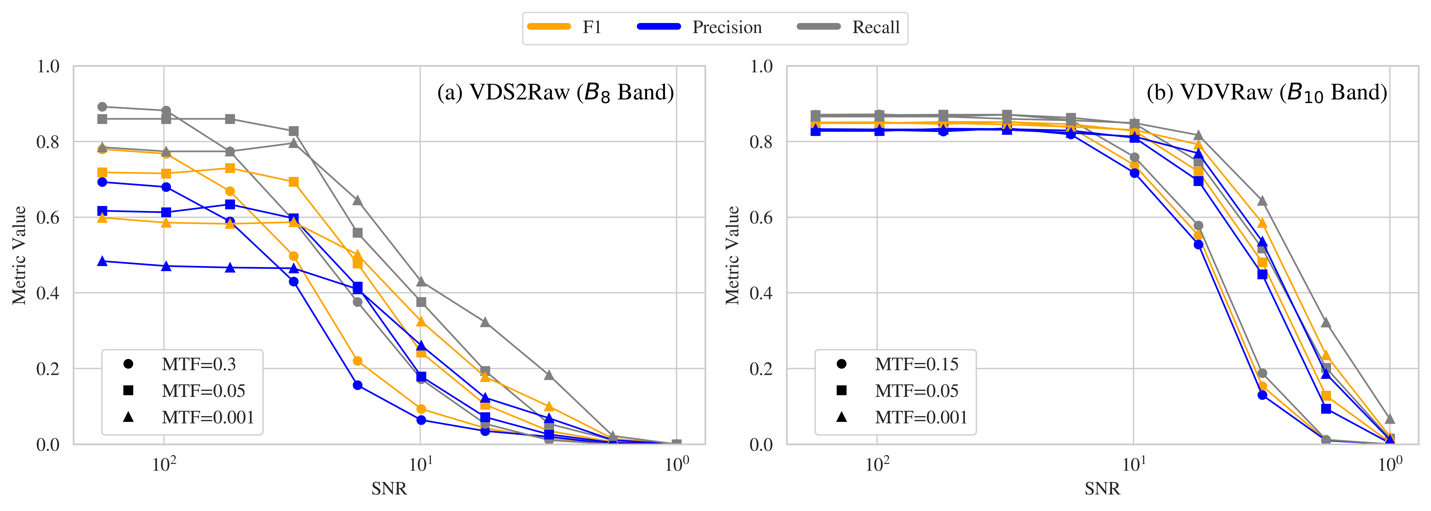
Secondly, to address the scarcity of raw satellite data, it introduced two novel datasets, VDS2Raw and VDV2Raw, which were derived from raw data from Sentinel-2 and Vegetation and Environment Monitoring New Micro Satellite (VENµS) missions, respectively, and enriched with Automatic Identification System (AIS) records.
Thirdly, it characterized the tasks' optimal single and multiple spectral band combinations through statistical and feature-based analyses validated on both datasets.
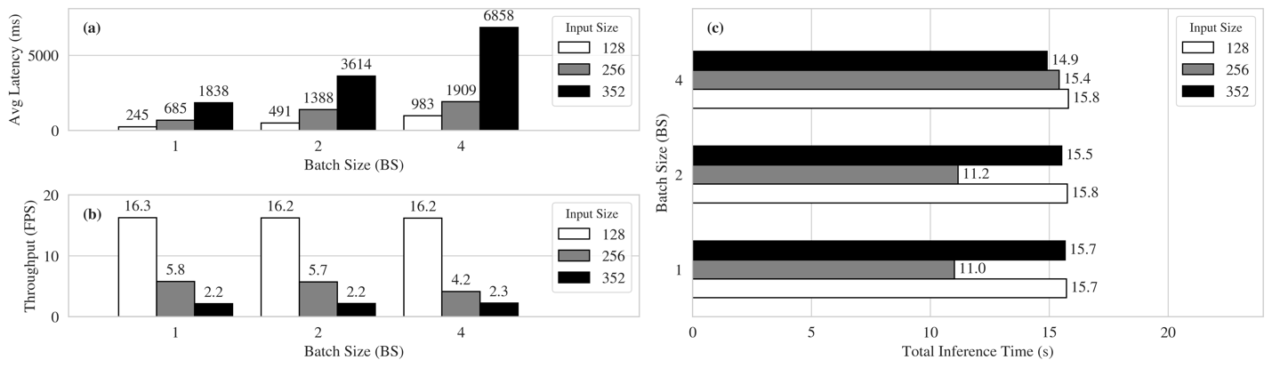
In sum, the project demonstrated the feasibility of the proposed method through a proof-of-concept on CubeSat-like hardware, confirming the models' potential for operational satellite-based maritime monitoring.
Development Tools
- TensorFlow
- PyTorch
- GPU, VPUs (Myriad2, MyriadX)
Development Outputs
- SimpleDet (https://github.com/sirbastiano/SimpleDet)
- Zenodo (10.5281/zenodo.14007820)
- R. Del Prete, M. Salvoldi, D. Barretta et al., “Enhancing Maritime Situational Awareness through End-to-End Onboard Raw Data Analysis”, IEEE JSTARS [Under Revision]
- D. Barretta et al., “Towards Real-Time Earth System Intelligence through Advancements in Onboard AI Processing”, IEEE GRSM [About To Submit]
- D. Barretta et al., “End-to-End Onboard Raw Data Processing for Earth Observation Applications”, ESA LPS 2025
- D. Barretta et al., “First Evaluation of Hybrid Quantum Neural Networks for Vessel Classification in Raw Multispectral Imagery”, IGARSS 2025
- G. Guerrisi, D. Barretta et al., “Preliminary Domain Gap Assessment of AI-based Onboard Image Compression for the Phisat-2 Mission”, IGARSS 2025
- A. Nowakowski et al., “Transfer Learning in Earth Observation Data Analysis – a review”, IEEE GRSM
- R. Del Prete, G. Meoni, M. Salvoldi, D. Barretta, et al., “Enhanced Maritime Monitoring via Onboard Processing of Raw Multi-Spectral Imagery by Deep Learning”, IGARSS 2024